


The earth is round, the map is flat
When calculating the distance between two latitudes and longitudes we need to take the fact that maps are flat, however, the Earth is three-dimensional (round) and is approximated as a sphere.

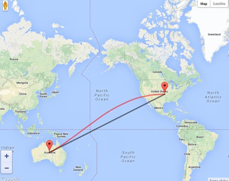
The black line is the shortest path possible but when plotting on flat map it will look like an arc (the red line). Therefore calculating distance between two coordinates needs to use very advanced mathematics.
Fortunately, with Google Maps API 3 libraries, Google Map offers a Geometry library which makes it very simple to calculate distance.
Google Maps geometry library provides functions for the computation of geometric data on the surface of the earth. All it requires is to call the computeDistanceBetween() function passing it two LatLng objects.
Loading the Maps JavaScript API
http://maps.google.com/maps/api/js?libraries=geometry&sensor=true&key=YOUR_API_KEY
Geometry Library Namespaces
- google.maps.geometry.spherical
Contains spherical geometry utilities allowing you to compute angles, distances & areas from coordinates (latitudes and longitudes).
- google.maps.geometry.encoding
Contains utilities for encoding and decoding paths for polylines and polygons. Useful to compress bulky list of coordintes.
Calculating Distance
var location1 = new google.maps.LatLng(38.715, -74.002);
var location2 = new google.maps.LatLng(41.506, -0.119);
var distance = google.maps.geometry.spherical.computeDistanceBetween(location1, location2);
Results are returned in meters.
Computing Heading
var location1 = new google.maps.LatLng(38.715, -74.002);
var location2 = new google.maps.LatLng(41.506, -0.119);
const heading = google.maps.geometry.spherical.computeHeading(
    location1,
    location2
  );
Results are returned in degrees from the north.
Calculating Area
var location1 = new google.maps.LatLng(38.715, -74.002);
var location2 = new google.maps.LatLng(41.506, -0.119);
var location3 = new google.maps.LatLng(20.916, -43.251);
var area = google.maps.geometry.spherical.computeArea([location1, location2, location3]);
Code above will calculate the area of a triangle between three locations provided to computeArea()
Conclusion
Calculating area, heading and distances on geo coordinates can be tricky and may require advanced mathematics, but with the help of the Google Maps Geometry Library it’s really simple. Thanks for reading.